Garmin GPSMAP 78
Garmin GPSMAP 78 Marine GPS Navigator User Manual
Model: GPSMAP 78 (010-00864-00)
Marka: Garmin
Sarrera
This manual provides comprehensive instructions for the Garmin GPSMAP 78 Marine GPS Navigator. It covers device setup, operation, maintenance, and troubleshooting to ensure optimal performance and user experience. The GPSMAP 78 is a rugged, marine-friendly handheld device designed for navigation in various environments, featuring a high-sensitivity GPS receiver and a color display.
Segurtasun Informazioa
OHARRA: Produktu honek Kaliforniako Estatuak minbizia eta jaiotza-akatsak edo ugalketa-kalte batzuk eragiten dituen produktu kimikoak ditu. Informazio gehiagorako, bisitatu www.P65Warnings.ca.gov.
Always exercise caution when operating any electronic device near water. Ensure battery compartment is securely sealed to maintain water resistance. Use only recommended battery types.
Hasteko
Kutxan dagoena
- Garmin GPSMAP 78 device
- Eskumuturreko uhala
- USB kablea
- Azkar hasteko eskuliburua
Bateriaren instalazioa
The GPSMAP 78 requires two AA batteries (not included). NiMH or Lithium batteries are recommended for optimal performance and battery life.
- Kokatu bateriaren konpartimendua gailuaren atzealdean.
- Ireki bateriaren konpartimenduaren estalkia.
- Sartu bi AA pila, polaritate markak errespetatuz (+ eta -).
- Close the battery compartment cover securely to ensure water resistance.
Garrantzitsua: The microSD card slot is located inside the waterproof battery compartment. Ensure the compartment is properly sealed after accessing the card slot to prevent water ingress.
Hasierako piztea
Eduki sakatuta Boterea button (usually marked with a power symbol) to turn on the device. Follow the on-screen prompts for initial setup, including language selection and time zone settings.
Funtzionamendu-argibideak
Gailua amaitu daview eta botoiak
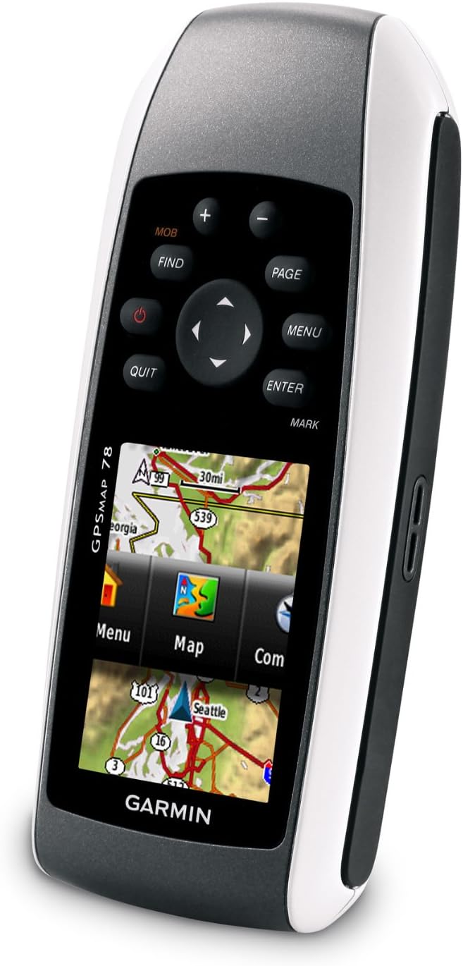
The Garmin GPSMAP 78 features a 2.6-inch color display and a series of buttons for navigation and control.

1. irudia: Aurrealdea view of the Garmin GPSMAP 78 handheld GPS unit. The image displays the device's 2.6-inch color screen, which shows a map of the Great Lakes region. Above the screen are buttons labeled 'MOB', 'FIND', 'PAGE', and '+' and '-'. Below the screen is a directional pad, and buttons labeled 'QUIT', 'MENU', 'ENTER', and 'MARK'. The Garmin logo is visible at the bottom.
- Pizteko botoia: Turns the device on/off, adjusts backlight.
- Zoom In/Out (+/-): Adjusts map zoom level.
- Orriaren botoia: Cycles through main pages (Map, Compass, Trip Computer, etc.).
- Menuko botoia: Opens the menu for the current page; press twice for main menu.
- Sartu botoia: Selects options, confirms actions.
- Quit Button: Cancels an action, returns to the previous page.
- Find Button: Accesses search functions for waypoints, geocaches, etc.
- Mark botoia: Zure uneko kokapena bide-puntu gisa markatzen du.
- MOB (Man Overboard) Button: Initiates a Man Overboard navigation.
- Norabideko Pad: Navigates menus and pans the map.
Nabigazioaren oinarriak
The GPSMAP 78 comes with a built-in worldwide basemap. Its high-sensitivity, WAAS-enabled GPS receiver and HotFix satellite prediction technology ensure quick and precise position acquisition, even in challenging environments like heavy tree cover or deep canyons.
- Viewing Your Position: On the Map page, your current location is indicated by a position icon.
- Panning the Map: Erabili norabide-panel-a mapa mugitzeko view.
- Zooma egitea: Erabili + eta - botoiak handitu edo txikitzeko.
Adding Maps
The device supports additional detailed maps via a microSD card.
- BlueChart g2: Preloaded cards for marine navigation.
- City Navigator NT: Map data for turn-by-turn routing on roads.
- BirdsEye satelite bidezko irudiak: Download satellite images (subscription required).
- Mapa pertsonalizatuak: Free software allows converting paper and electronic maps into downloadable maps for the device.
To install a microSD card, open the battery compartment, insert the card into the slot, and then securely close the compartment.
Bide puntuak, ibilbideak eta pistak
- Bide-puntuak: Mark specific locations. Press the MARKATU button to save your current location as a waypoint.
- Ibilbideak: Create a sequence of waypoints to navigate a planned path.
- Pistak: Record your path as you travel. The device automatically records a track log.
Geocachinga
The GPSMAP 78 supports geocaching GPX files. You can download geocaches and their details directly to your unit, eliminating the need for manual coordinate entry or paper printouts. The device stores and displays key information such as location, terrain, difficulty, hints, and descriptions.
Konektibitatea
Connect your GPSMAP 78 to a computer using the provided USB cable to manage data and interact with Garmin Connect.
- Garmin Connect: Upload activities, analyze data, view tracks on a map, and share experiences.
- Datuen transferentzia: Transfer waypoints, routes, and tracks between your device and computer.
Mantentzea
Gailua garbitzea
Clean the device with a cloth dampened with a mild detergent solution. Avoid using abrasive cleaners or solvents that could damage the device's surfaces.
Uraren Erresistentzia
The GPSMAP 78 is waterproof to IPX7 standards and floats in water. This means it can withstand incidental exposure to water of up to 1 meter for 30 minutes. However, it is not designed for continuous submersion. Always ensure all covers, especially the battery compartment, are securely closed to maintain water resistance.
2. irudia: Angelukoa view of the Garmin GPSMAP 78, highlighting its molded rubber side grips for enhanced handling. The screen displays a menu interface with options like "Menu", "Map", and "Com".
Biltegiratzea
When storing the device for extended periods, remove the batteries to prevent leakage and potential damage. Store in a cool, dry place away from direct sunlight.
Arazoak konpontzea
Gailua ez da pizten
- Ziurtatu bateriak behar bezala instalatuta daudela polaritate egokiarekin.
- Replace old batteries with fresh AA batteries (NiMH or Lithium recommended).
- Check if the battery compartment cover is fully closed.
Poor GPS Signal Reception
- Ziurtatu gailuak argia duela view zeruko.
- Avoid operating in areas with dense foliage, tall buildings, or indoors.
- Allow sufficient time for the device to acquire satellites (HotFix technology assists in faster acquisition).
Maps Not Displaying Correctly
- Verify that the microSD card containing the maps is properly inserted.
- Ensure the map products are compatible with the GPSMAP 78.
- Check map settings within the device to ensure desired maps are enabled.
Zehaztapenak
| Produktuaren neurriak | 1.2 x 2.6 x 6 hazbete |
| Elementuaren pisua | 7.7 ontza |
| Bistaratzeko tamaina | 2.6 inches diagonal (1.43" x 2.15") |
| Bistaratzeko ebazpena | 160 x 240 pixel |
| Memoria | 1.7 GB |
| Bateria mota | 2 AA batteries (NiMH or Lithium recommended) |
| Bateriaren iraupena | Gehienez 20 ordu |
| Uraren balorazioa | IPX7 (floats) |
| Konektibitatea | USBa |
| Ezaugarri bereziak | High-sensitivity receiver, WAAS-enabled, HotFix, Geocaching, Custom POIs, Garmin Connect Compatible |
Bermea eta Laguntza
For information regarding warranty coverage, product support, or service, please refer to the official Garmin website or contact Garmin customer support directly. Keep your purchase receipt as proof of purchase.
Online resources, including software updates and additional manuals, may be available on the Garmin support portal.
Ask a question about this manual
Ask about setup, troubleshooting, compatibility, parts, safety, or missing instructions. Manuals+ will review the question and use this page’s manual context to help answer it.